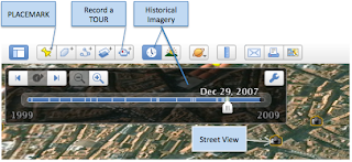
 We went through the basic navigation quickly since I thought it would be cool to play around with some of the PLACES and LAYERS panels. We had a birds-eye view of Madrid (Spain) and marked our own places (called place-marking). We were able to see 3-D renditions of monuments, look at live weather, come eye-level close to the streets of Madrid (amazing!) and literally walk up and down these streets (called ‘street view’). We were able to look at historical imagery (a time-line of sorts) and see how it has changed over time. I could tell the workshop attendees were having a lot of fun!
 One of the best (and overlooked) feature is ‘recording a tour’ (requires some prior planning). The best way to use it is to have placemarks of places that you want to show and then record a tour (with your own voice-over) along with photos, 3-D views, current weather conditions and the whole enchilada. Your imagination will run crazy!
I encourage educators (and others) to look at GE closely and see how such related information can be added to your info-bank as you make your classes more visual and interactive.
Technologies: Google Earth, Youtube, Online Images
Contact me:
Sujan Manandhar
Technology Integration Specialist,
Foreign Language Center
Ohio State University